-
 Homann Heirs, Partie Occidentale de la Nouvelle France ou du Canada, 1755£ 3,650.00
 -
Andrea Scacciati, Carta rappresentante i cinque Laghi del Canada, 1763£ 675.00
-
Antonio Zatta, La Pensilvania La Nuova York, Il Jersey Settentriole, Con La Parte Occidentale Del Connecticut, Massachusset-S-Bay E L'Irochesia, 1779£ 825.00
-
Rigobert Bonne, Kaart - Kanada, 1790 c.£ 425.00
-
Morris Birkbeck, Map of part of the United States of North America with the Territory of Illinois on the Ohio particularly designed to illustrate Birkbeck's Journey, 1818£ 1,250.00
-
Carey & Lea, Geographical, Statistical, and Historical Map of Ohio, 1823£ 875.00
-
John Cary, A New Map of Part of the United States exhibiting the North West, Michigan, Indiana, and Illinois Territory, the States of Kentucky, Ohio, Virginia, Maryland and Pennsylvania from the Latest Authorities, 1825£ 3,650.00
-
Philippe Vandermaelen, Partie des Etats-Unis. (50), 1827£ 550.00
-
Map of the States of Indiana and Ohio with Part of Michigan Territory, 1832I.T. HintonSeries: LondonI.T. Hinton, Map of the States of Indiana and Ohio with Part of Michigan Territory, 1832£ 295.00
-
Society for the Diffusion of Useful Knowledge (SDUK), North America Sheet VIII, 1833£ 92.00
-
David H. Burr, Map of the Northern Parts of Ohio, Indiana and Illinois with Michigan and that Part of the Ouisconsin Territory lying east of the Mississippi River, 1836£ 975.00
-
Samuel Augustus Mitchell, Map of the Chief Part of the Western States and Part of Virginia, 1839£ 145.00
-
Joseph Meyer, Neueste Karte von Ohio, 1845£ 245.00
-
Samuel Augustus Mitchell, A New Map of Ohio, 1846£ 225.00
-
Joseph Hutchins Colton, The Cities of Pittsburgh and Allegheny - The City of Cincinnati, 1855£ 88.00
-
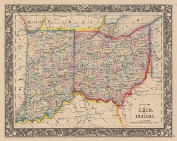
Samuel Augustus Mitchell, County Map of Ohio and Indiana, 1860£ 125.00
-
Johnson & Browning, Johnson's Ohio and Indiana, 1861£ 195.00
-
Johnson & Ward, Johnson's Ohio, 1864£ 295.00
-
Samuel Augustus Mitchell, County & Township Map of the States of Ohio and Indiana, 1882£ 140.00
-
Letts & Son, Eastern United States, 1882£ 75.00
-
Samuel Augustus Mitchell, Plan of Cincinnati and vicinity, 1884 c.£ 64.00
-
Arbuckle Brothers Company, [Ohio], 1889£ 98.00
-
George Cram, Ohio - North half, 1897£ 195.00
-
George Cram, [Southern Ohio], 1897£ 195.00
-
J.A. Stewart, City of Cincinnati, Ohio, 1898£ 925.00
-
A.H. Mueller, Map of the City of Cleveland, 1898£ 650.00
-
Columbus Lithograph, Railroad Map of Ohio, 1904£ 295.00
-
Karl Baedeker, Cleveland, 1908£ 58.00
-
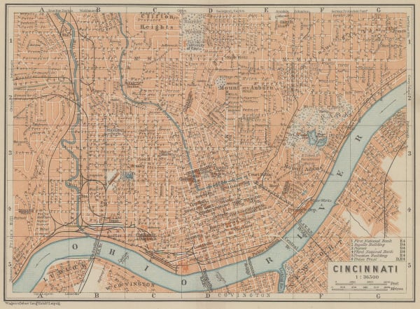
Karl Baedeker, Cincinnati, 1909£ 44.00
-
Arthur B. Suchy, The Heart of Cleveland Ohio, 1928£ 495.00
-
Arthur B. Suchy, Mother of Presidents, 1950 c.£ 245.00
Close
Search Inventory
Our entire inventory of over 10,000 antique and vintage maps is now available to browse by region, date, cartographer, and subject


![Arbuckle Brothers Company, [Ohio], 1889](https://artlogic-res.cloudinary.com/w_600,c_limit,f_auto,fl_lossy,q_auto/artlogicstorage/themaphouse/images/view/13651e3ac2c8d5eaf4b92c7cc5d1d419j/themaphouse-arbuckle-brothers-company-ohio-1889.jpg)

![George Cram, [Southern Ohio], 1897](https://artlogic-res.cloudinary.com/w_600,c_limit,f_auto,fl_lossy,q_auto/artlogicstorage/themaphouse/images/view/4316bf2a0e4dd422bc0b65a5dbbf7af4j/themaphouse-george-cram-southern-ohio-1897.jpg)


Join our mailing list
* denotes required fields
We will process the personal data you have supplied to communicate with you in accordance with our Privacy Policy. You can unsubscribe or change your preferences at any time by clicking the link in our emails.
![]()