-
 Martin Waldseemüller & Laurent Fries, Early Woodcut Map of Spain & Portugal, 1541£ 2,850.00
 -
Claudius Ptolemy & Laurent Fries, Ptolemaic Map of Spain & Portugal, 1541£ 2,150.00
-
Sebastian Münster, Spain & Portugal, 1558£ 495.00
-
Giovanni Antonio Magini, Spain & Portugal, 1596£ 325.00
-
Mercator Hondius, Spain & Portugal, 1621£ 295.00
-
Matthäus Merian, Spain & Portugal, 1640 c.£ 495.00
-
John Speed, Spaine Newly described with many adictions, 1676£ 1,950.00
-
Robert Morden, A New Map of Hispania and Portugallia, 1688£ 185.00
-
Cornelis & Justus Danckerts, Accuratissima Totius Regni Hispaniae Tabula, 1690 c.£ 695.00
-
Frederick De Wit, Hispaniae et Portugalliae, 1690 c.£ 800.00
-
Philipp Cluver, Hispaniae Veteris et Novae Descriptio, 1697£ 295.00
-
Herman Moll, A New and Exact Map of Spain and Portugal, 1711£ 2,750.00
-
Pieter van der Aa, L'Espagne, 1714£ 395.00
-
Jacques Chiquet, L'Espagne, 1719£ 295.00
-
Herman Moll, Spain and Portugal, 1720 c.£ 150.00
-
Johann Georg Schreiber, Spanien und Potugal, 1720 c.£ 225.00
-
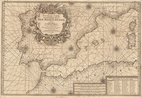
Henri Michelot and Laurent Brémond, Nouvelle Carte Generalle de la Mer Mediterranee, 1726£ 2,650.00
-
Covens (Jean) & Mortier (Cornelius), L'Espagne, 1730 c.£ 285.00
-
Covens (Jean) & Mortier (Cornelius), Nova Regni Hispaniae Accurata Descriptio ad Usum Serenissimi Burgundiae Ducis, 1730 c.£ 385.00
-
Covens (Jean) & Mortier (Cornelius), Novissima et Accuratissima Regnorum Hispaniae et Portugalliae, 1730 c.£ 650.00
-
Jean Baptiste Nolin, El Reyno De Espana, 1740£ 750.00
-
Matthaus Seutter, Hispania, 1740 c.£ 495.00
-
Homann Heirs, Regnorum Hispaniae et Portugalliae, 1740 c.£ 600.00
-
Georges-Louis Le Rouge, L'Espagne Suivant les Nouvelles Observations, 1746£ 125.00
-
Elias Baeck, L'Espange comprend tant en Longeur qu'en Largeur environ 180 Lieues d'Allemagne., 1748£ 275.00
-
T. & E. Bowen, A New & Accurate Map of Spain and Portugal, 1750 c.£ 280.00
-
Tobias Conrad Lotter, Regnorum Hispaniae et Portugalliae Tabula Generalis, 1755 c.£ 125.00
-
London Magazine, Spain and Portugal, 1761£ 78.00
-
Andrew Dury, Spain and Portugal | Espagne et Portugal, 1761£ 195.00
-
Étienne André Philippe de Prétot, L'Italie Meridionale, 1768£ 95.00
-
Isaac Tirion, Nieuwe Kaart van Spanje en Portugal, 1769£ 220.00
-
William Faden, A Chart of the Coasts of Spain and Portugal, with The Balearic Islands, and part of the Coast of Barbary, 1780£ 425.00
-
Francois Santini, Les Royaumes D'Espagne et de Portugal, 1780 c.£ 275.00
-
John Harrison, A Chart of the English Channel with the Coasts of France, Spain, and Portugal, 1784£ 95.00
-
Robert Sayer, A New Map of the Kingdoms of Spain and Portugal with their Principle Divisions, 1790£ 195.00
-
Robert Wilkinson, A Map of Spain & Portugal, 1791£ 125.00
-
Laurie & Whittle, A New Map of the Kingdoms of Spain and Portugal with their Principle Divisions, 1794£ 445.00
-
Charles Francois Delamarche, Royaumes d'Espagne et de Portugal, 1795£ 195.00
-
John Russell, Spain and Portugal, 1795£ 48.00
-
Bowles & Carver, Bowles's New One-Sheet Map of The Kingdoms of Spain and Portugal, 1795 c.£ 245.00
-
William Faden, Spain and Portugal, 1796£ 445.00
-
John Russell, Spain and Portugal, 1799£ 145.00
-
George Cooke, Spain and Portugal, 1802£ 125.00
-
William Faden, A New Map of Spain and Portugal [...] requisite for the Intelligence of Military Operations, 1810£ 2,250.00
-
John Russell, Spain and Portugal, 1810£ 55.00
-
John Cary, A New Map of Spain and Portugal, 1811£ 150.00
-
C.V. Lavoisne, Geographical and Statistical Map of Spain and Portugal, 1813£ 195.00
-
John Thomson, Spain & Portugal, 1815£ 165.00
-
Matthew Carey, Spain and Portugal, 1818£ 95.00
-
William Faden, Hispania Vetus, 1819£ 78.00
-
Adrien Brue, Carte de L'Espagne Ancienne, 1828£ 95.00
-
Thomas Starling, Spain, 1830 c.£ 58.00
-
Alexandre Emile Lapie, Carte de la Peninsule Comprenant L'Espagne et le Portugal, 1831£ 90.00
-
Society for the Diffusion of Useful Knowledge (SDUK), Spain and Portugal, 1838£ 45.00
-
W. & A.K. Johnston, Spain and Portugal, 1840 c.£ 115.00
-
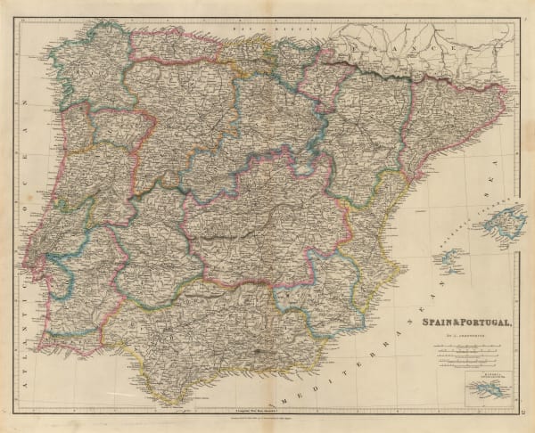
John Arrowsmith, Spain & Portugal, 1842£ 125.00
-
Henry Teesdale, Spain & Portugal, 1845£ 75.00
-
Samuel Augustus Mitchell, Spain and Portugal, 1846£ 88.00
-
Joseph Meyer, Spanian, 1847£ 65.00
-
Gall & Inglis, Map of Spain and Portugal, 1850 c.£ 30.00
-
James Wyld, Spain and Portugal, 1850 c.£ 425.00
-
John Rapkin, Spain and Portugal, 1850 c.£ 85.00
-
George Philip, Spain and Portugal, 1850 c.£ 145.00
-
Henry George Collins, Spain and Portugal, 1850 c.£ 64.00
-
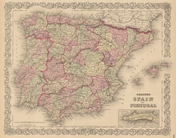
George Woolworth Colton, Colton's Spain and Portugal, 1855£ 90.00
-
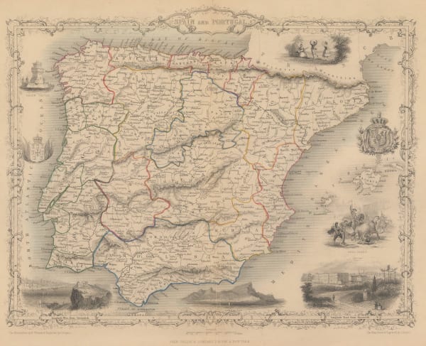
John Tallis, Spain and Portugal, 1855£ 245.00
-
Joseph Meyer, Neueste Karte von Spanien und Portugal, 1855 c.£ 95.00
-
Auguste-Henri Dufour, Carte Administrative, Physique et Routiere De L'Espagne et Du Portugal, 1857£ 2,450.00
-
F.A. Brockhaus, Spanien und Portugal, 1859£ 380.00
-
Archibald Fullarton, Spain & Portugal, 1860 c.£ 85.00
-
Edward Weller, Spain and Portugal, 1863£ 52.00
-
John Dower, Spain and Portugal, 1871£ 58.00
-
Heinrich C. Kiepert, Spanien und Portugal, 1877£ 72.00
-
Justus Perthes, Spanien und Portugal, 1885£ 45.00
-
G. & J. Bartholomew, Spain and Portugal, 1886£ 32.00
-
Arbuckle Brothers Company, [Spain], 1889£ 125.00
-
J. Migeon, Espagne et Portugal, 1890 c.£ 42.00
-
George Philip & Son Ltd., Spain and Portugal, 1896£ 28.00
-
George Philip & Son Ltd., Spain & Portugal: Industries & Communications, 1910 c.£ 115.00
-
Patronato Nacional del Turismo (P.N.T), Exposicion General Espanola, 1928 c.£ 125.00


![William Faden, A New Map of Spain and Portugal [...] requisite for the Intelligence of Military Operations, 1810](https://artlogic-res.cloudinary.com/w_600,c_limit,f_auto,fl_lossy,q_auto/artlogicstorage/themaphouse/images/view/f1e3955f993a2b36fd03d1f3f6319d77j/themaphouse-william-faden-a-new-map-of-spain-and-portugal-...-requisite-for-the-intelligence-of-military-operations-1810.jpg)


![Arbuckle Brothers Company, [Spain], 1889](https://artlogic-res.cloudinary.com/w_600,c_limit,f_auto,fl_lossy,q_auto/artlogicstorage/themaphouse/images/view/a2d6278298c81d7621eee8d932e1706bj/themaphouse-arbuckle-brothers-company-spain-1889.jpg)


Page
1
of 2