-

-
John Thomson, A Comparative View of the Mountains of the World, 1822 c£ 850.00
-
John Thomson, Plan of the Lengths of the Principal Rivers of the World, 1822 c£ 850.00
-
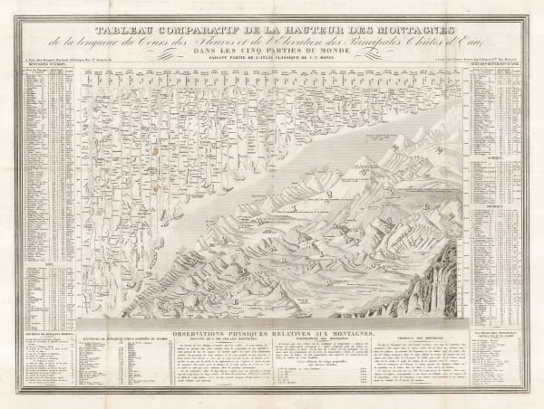
Charles V. Monin, Comparative View of the Mountains, Rivers & Waterfalls of the World, 1839 c.£ 1,750.00
-
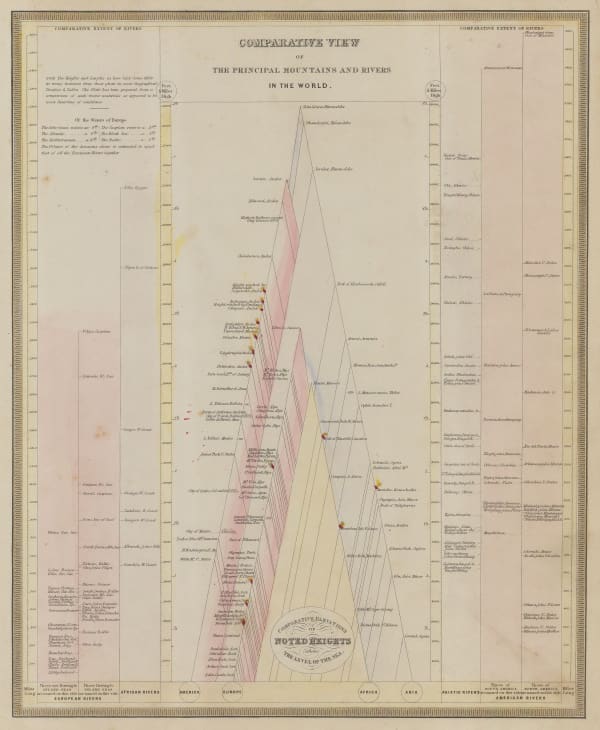
Sidney Hall, Compartative View of the Principal Mountains and Rivers in the World, 1840 c.£ 475.00
-
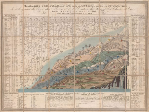
Charles V. Monin, Tableau Comparatif de la Hauteur des Montagnes, 1840 c.£ 475.00
-
Ashford & Loader, The Heights of the Mountains of the Eastern Hemisphere, 1845£ 975.00
-
James Reynolds, Waterfalls, 1846 c.£ 495.00
-
W. & A.K. Johnston, Geographical Division and Distribution of Aves (Birds) over the World, 1848£ 625.00
-
W. & A.K. Johnston, Zoological Geography, 1848£ 595.00
-
W. & A.K. Johnston, Zoological Geography, 1848£ 495.00
-
Jean Andriveau-Goujon, Comparative View of the World's Mountains and Volcanoes, 1850£ 1,200.00
-
James Reynolds, The Hills and Mountains of the British Isles, 1852£ 650.00
-
George Aikman, Physical Geography, 1855 c.£ 295.00
-
Henry William Blair, New York City's Drinking Problem, 1888£ 985.00
-
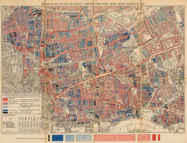
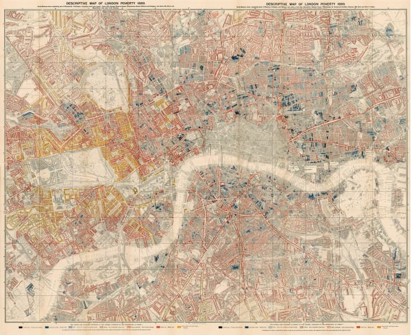
Charles Booth, First Edition Poverty Map of the East End, 1889£ 4,500.00
-
-
Charles Booth, Charles Booth's Poverty Map of London (NE), 1889£ 3,750.00
-
Charles Booth, Charles Booth's Poverty Map of London (NW), 1889£ 3,750.00
-
Charles Booth, Charles Booth's Poverty Map of London (SE), 1889£ 2,750.00
-
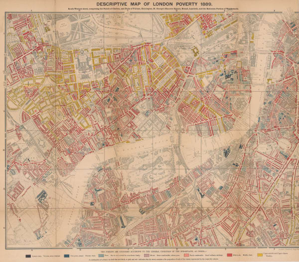
Charles Booth, Charles Booth's Poverty Map of London (SW), 1889£ 4,750.00
-
Charles Booth, Fulham, West Brompton, & Earl's Court, 1890 c.£ 950.00
-
Charles Booth, Putney & Wandsworth, 1890 c.£ 450.00
-
Charles Booth, Inner North West [Booth Poverty Map], 1891£ 985.00
-
Charles Booth, Battersea & Clapham Poverty Map, 1900£ 1,650.00
-
Charles Booth, Poverty Map of Greenwich, Deptford & Lewisham, 1900£ 1,275.00
-
Charles Booth, Poverty Map of Hoxton, Clerkenwell & Old Street, 1900£ 675.00
-
Charles Booth, Poverty Map of Stoke Newington, Dalston, Haggerston & Hackney, 1900£ 795.00
-
Charles Booth, Poverty Map of South London, 1900£ 1,550.00
-
Charles Booth, Map Showing Places of Religious Worship, Public Elementary Schools, and Houses Licensed for the Sale of Intoxicating Drinks, 1900£ 2,950.00
-
Charles Booth, New North London, 1900£ 1,350.00
-
Charles Booth, Poverty Map of Bow, Poplar, Stepney & Limehouse, 1900£ 745.00
-
Charles Booth, Poverty Map of Peckham, Brixton & Camberwell, 1900£ 1,250.00
-
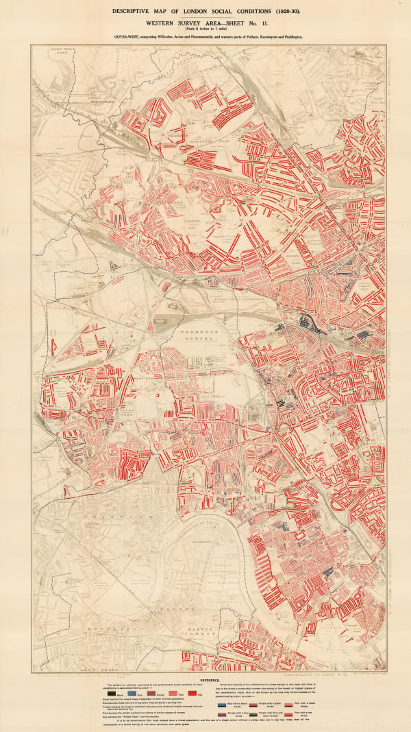
Charles Booth, The Outer West [Poverty Map], 1900£ 1,650.00
-
Charles Booth, West Central London, 1900£ 925.00
-
Charles Booth, Hampstead and St. John's Wood, 1900 c.£ 1,350.00
-
Charles Booth, The Inner West, 1900 c.£ 4,950.00
-
Charles Booth, Poverty Map of Woolwich & Plumstead, 1902£ 325.00
-
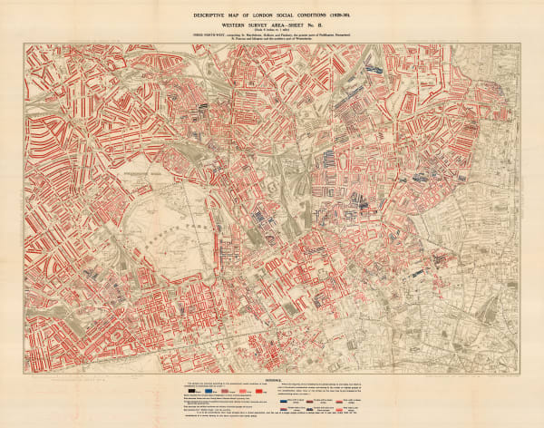
Charles Booth, Descriptive Map of London Social Conditions (1929-1930), 1930£ 1,950.00
-
Charles Booth, Descriptive Map of London Social Conditions (1929-1930), 1930£ 1,550.00
-
Charles Booth, Poverty Map of Whitechapel, Hackney, Shoreditch & Stratford, 1930£ 1,350.00
-
Charles Booth, Descriptive Map of London Social Conditions (1929-1930), 1930£ 950.00
-
Charles Booth, Poverty Map of Tottenham, Stoke Newington, Leyton & Walthamstow, 1930£ 850.00
-
Charles Booth, Poverty Map of Wandsworth, Streatham, Tooting, Clapham & Dulwich, 1930£ 1,450.00
-
Charles Booth, Poverty Map of Royal Docks, Barking & Woolwich, 1930£ 650.00
-
Charles Booth, Poverty Map of Lewisham, Sydenham, Deptford & Eltham, 1930£ 750.00
-
Charles Booth, Descriptive Map of London Social Conditions (1929-1930), 1930£ 2,500.00
-
Charles Booth, Map of Overcrowding in the London Survey Area (1931), 1931£ 1,950.00
-
Harrap & Co., Ltd., U.S.S.R. Agriculture and Fur-Bearing Animals, 1946£ 295.00
-
Harrap & Co., Ltd., U.S.S.R. Industries and Mineral Deposits, 1946£ 395.00
-
A.J. Dilloway, The Displacement of Jews in Europe, 1947£ 85.00
-
Pict. Charts Service, USA and the World Today, 1949£ 695.00
Close
Search Inventory
Our entire inventory of over 10,000 antique and vintage maps is now available to browse by region, date, cartographer, and subject


![Charles Booth, Inner North West [Booth Poverty Map], 1891](https://artlogic-res.cloudinary.com/w_600,c_limit,f_auto,fl_lossy,q_auto/artlogicstorage/themaphouse/images/view/e891883215067dc48512a8580493a4e2j/themaphouse-charles-booth-inner-north-west-booth-poverty-map-1891.jpg)


![Charles Booth, The Outer West [Poverty Map], 1900](https://artlogic-res.cloudinary.com/w_600,c_limit,f_auto,fl_lossy,q_auto/artlogicstorage/themaphouse/images/view/6858a33b669dc7b40e05d1fb339f7dc2j/themaphouse-charles-booth-the-outer-west-poverty-map-1900.jpg)


Join our mailing list
* denotes required fields
We will process the personal data you have supplied to communicate with you in accordance with our Privacy Policy. You can unsubscribe or change your preferences at any time by clicking the link in our emails.
![]()