-

-
Vincenzo Coronelli, Mare del Sud, 1690 c.£ 2,750.00
-
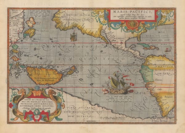
Pierre Mortier, Mer de Sud ou Pacifique, 1708£ 3,450.00
-
Alain Manesson Mallet, Isles de Salomon, 1719£ 225.00
-
-
Carte Reduite Des Mers Comprises Entre L'Asie et L'Amerique, 1742Jacques-Nicolas BellinSeries: ParisJacques-Nicolas Bellin, Carte Reduite Des Mers Comprises Entre L'Asie et L'Amerique, 1742£ 3,750.00
-
Jacques-Nicolas Bellin, Carte de L'Archipel de St. Lazare ou les Isles Marianes, 1752£ 68.00
-
Robert de Vaugondy, Discoveries in the North Pacific according to a Japanese World Map, 1772£ 695.00
-
Capt. James Cook, Carte d'une partie de la Mer Du Sud, 1774£ 1,550.00
-
Robert Sayer, Russian Discoveries in Siberia, Alaska & the Bering Strait, 1775£ 1,325.00
-
Tobias Conrad Lotter, James Cook's Voyage to the North Pacific & Bering Strait, 1781£ 2,750.00
-
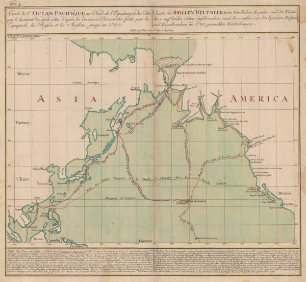
Gerhard Friedrich Muller, Russian Discoveries in Siberia, Alaska & the Bering Strait, 1784£ 1,200.00
-
John Stockdale, A Chart of Lord Howe Island, 1789£ 345.00
-
John Stockdale, A Chart of the Track of the Alexander on Her Homeward Passage from Port Jackson on East Coast of New South Wales to Batavia, 1789£ 195.00
-
John Stockdale, A Chart of the Track of the Scarborough on her Homeward Passage, 1789£ 245.00
-
Emanuel Bowen, A New & Accurate Chart of the Discoveries made by the late Capt. Js. Cook, 1790 c.£ 895.00
-
Capt. James Cook, Carte de l'Isle d'Otahiti, 1790 c.£ 575.00
-
Capt. James Cook, Kaart van de Ontdekkingen in de Stille Zuid-Zee, Gedaan met S'Konings Schip De Resolutie, onder bevel van Kapitein Cook, in het Jaar 1774., 1794£ 185.00
-
Capt. James Cook, Paasch-Eiland, 1794£ 125.00
-
John Meares, The North Pacific Ocean, 1795 c.£ 675.00
-
Jean Francois de La Perouse, Partie de la Mer du Sud Comprise Entre les Philipinnes et la Californie, 1797£ 430.00
-
Count Jean-Francois de la Perouse, Carte de Cotes de L'Amerique et de L'Asie depuis la Californie jusqu'a Macao, 1797£ 750.00
-
Christoph & Johann Christoph Weigel, Karte von Australien oder Polynesien, 1800 c.£ 1,750.00
-
Cadell & Davies, Alaska, Kamchatka & the Bering Strait, 1802£ 295.00
-
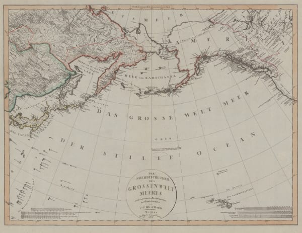
Christian Gottlieb Reichard, Chart of the North Pacific Ocean, 1804£ 785.00
-
Johann Christoph Reinecke, General Chart von Australien, 1804£ 885.00
-
William Faden, James Cook's Voyage to Alaska & the Bering Strait, 1808£ 2,850.00
-
Johann Christoph Reinecke, General Charte Von Australia, 1812£ 1,950.00
-
Christian Gottlieb Reichard, Karte vom FunftenErdteil oder Australien, 1813£ 1,550.00
-
John Thomson, New Holland and Asiatic Isles, 1814£ 1,675.00
-
-
John Thomson, Southern Hemisphere, 1814£ 675.00
-
John Thomson, Chart of the Northern Passage between Asia & America, 1816£ 525.00
-
Rigobert Bonne, Australie, 1817£ 380.00
-
Friedrich Wilhelm Streit, Charte von Australien, 1817£ 1,250.00
-
John Thomson, Map of the Islands in the Pacific Ocean, 1817£ 445.00
-
John Pinkerton, Australasia, 1818£ 1,795.00
-
Jean Francois de La Perouse, Carte Reduite du Grand Ocean, 1818£ 725.00
-
John Wilkes, Polynesia and Australasia, 1825£ 68.00
-
Philippe Vandermaelen, Tonga, 1827£ 325.00
-
Philippe Vandermaelen, Fiji, 1827£ 545.00
-
Philippe Vandermaelen, French Polynesia, Tahiti & Bora Bora, 1827£ 245.00
-
Philippe Vandermaelen, North-western Solomon Islands, 1827£ 445.00
-
Edmond Francois Paris, Plan de L'Isle Tanga-Tabou, 1827£ 275.00
-
Alexandre Emile Lapie, Carte De L'Oceanie - Contenant L'Australie, La Polynesie et Les Isles Asiatiques, 1829£ 175.00
-
Carl Weiland, Australien, 1830£ 875.00
-
Thomas Starling, South Sea Islands, 1830 c.£ 115.00
-
Joshua Archer, Australasia, 1833£ 55.00
-
Clement Adrien Vincendon-Dumoulin, Carte de l'Archipel Viti, 1838£ 595.00
-
W. & A.K. Johnston, Islands in the Pacific Ocean, 1840 c.£ 80.00
-
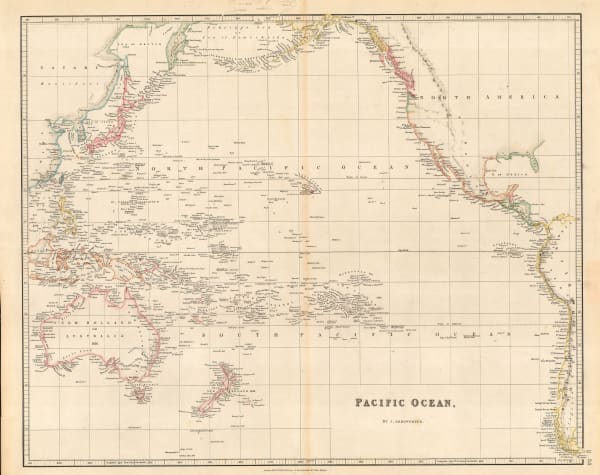
John Arrowsmith, Pacific Ocean, 1842£ 185.00
-
Royal Geographical Society (RGS), Eastern Archipelago, 1845£ 345.00
-
Joseph Meyer, Neuste Karte von Australien, 1846£ 165.00
-
Samuel Augustus Mitchell, Oceana or Pacific Ocean, 1846£ 225.00
-
Henry Teesdale, Chart of the Pacific Ocean, 1847£ 275.00
-
Joseph Meyer, Der Grosse Ocean und Australien, 1849£ 120.00
-
Justus Perthes, Ost-Polynesien, 1849£ 88.00
-
Gall & Inglis, Map of Islands in the Pacific Ocean, 1850 c.£ 88.00
-
James Wyld, The Basin of the Pacific, 1850 c.£ 875.00
-
George Philip & Son Ltd., Alaska, Kamchatka & the Bering Strait, 1853£ 575.00
-
Charles V. Monin, Oceanie, 1853£ 125.00
-
George Philip, Islands in the Pacific Ocean, 1856£ 250.00
-
Carl & Adolf Graf, Australien, 1857£ 325.00
-
F.A. Garnier, Oceanie, 1860£ 225.00
-
Victor Levasseur, Océanie, 1860 c.£ 275.00
-
Justus Perthes, Die Tonga Inseln, 1869£ 45.00
-
Justus Perthes, Edbeben-Fluth im Pacifischen Ocean, 13-16 August 1868, 1869£ 65.00
-
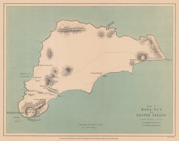
Royal Geographical Society (RGS), Chart of Rapa-Nui or Easter Island, 1870£ 275.00
-
Justus Perthes, Die Inneln des Grossen Oceans, 1870£ 50.00
-
Archibald Fullarton, Oceania and Pacific Ocean, 1870 c.£ 115.00
-
John Dower, Pacific Ocean, 1871£ 80.00
-
Society for the Diffusion of Useful Knowledge (SDUK), The Islands of New Zealand, 1875£ 625.00
-
Adrien Brue, Carte Generale de L'Oceanie, 1876£ 145.00
-
G. & J. Bartholomew, Oceania, 1887£ 38.00
-
Scottish Geographical Society (SGS), Coral Reefs in the Pacific Ocean, 1888£ 195.00
-
John Murray, Sydney to Wellington, 1890£ 295.00
-
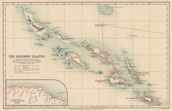
Royal Geographical Society (RGS), The Solomon Islands, 1890£ 225.00
-
Justus Perthes, Grosser Ocean, 1895£ 38.00
-
G. & J. Bartholomew, Australasia - General Commercial Chart, 1906£ 120.00
-
George Philip & Son Ltd., Australasia: Industries & Communications, 1910 c.£ 145.00


Page
1
of 2